Impacts of COVID-19 as Seen Using Big Data from Space
- Space4Good

- Sep 24, 2020
- 3 min read
Space4Good and World Bank collaborate on the Big Data NO2 Socio-Economic Observatory
With the slowing of human mobility - and as a result, economic activity - across the globe due to the COVID-19 pandemic, air pollution has declined significantly in several countries, namely China, Italy, South Korea, and the United Kingdom (Figure 1).

Figure 1. Nitrogen Dioxide emissions over China December through March 2020. Source: European Space Agency (ESA). Full animation available here.
At Space4Good, we have teamed up with the World Bank to assess local air quality indicators (AQI). In many cases, these are a mainstay in many people’s lives - checking the local AQI levels on their smartphones just as they would check the weather. The measurement of one of the air quality components – nitrogen dioxide, or NO2 – is seeing a paradigm shift in real-time data measurement through remote sensing.
While NO2 satellite measures have been discussed widely during the COVID-19 pandemic, there is much that can be done to make this information more accessible and meaningful to local citizens and policy- and decision-makers across the world.
Together with the World Bank Group, Space4Good developed a nitrogen dioxide (NO2) monitoring platform which provides economists and decision-makers an alternative big data source to observe changes in socio-economic activities. Using novel satellite systems, we were able to provide city-level accuracy for Indonesia, Vietnam, and selected MENA cities.
The Sentinel-5 Precursor – or the, Sentinel-5P – is the first Copernicus mission dedicated to monitoring our atmosphere. The satellite carries the TROPOMI instrument to map a multitude of trace gases such as nitrogen dioxide, ozone, formaldehyde, sulphur dioxide, methane, carbon monoxide, and aerosols – all of which affect the air we breathe (Figure 2).

Figure 2. Sentinel 5 Precursor air quality monitoring. Source: UP42.
Human activities involving fossil fuel combustion (coal, gas, and oil) release Nitrogen Monoxide (NO). As such, NO2 measurements can act as a proxy for human activity and a global indicator for national and sub-national socio-economic activity. A local analysis explores the NO2 patterns and behaviors across different areas in Indonesia and Vietnam before and during the COVID-19 crisis. Although the pandemic is a shared event, these areas show individual fingerprints and unique behaviors to this global situation.
The presence of the NO2 hotspots in Indonesia, shown in yellow (Figure 3), provides an indication of the socio-economic activity present on the ground. All these clusters coincide with metropolitan areas characterized by a high population, industrial operations, and traffic. These all contribute to NO2 emissions, thus providing validity to the satellite-derived data.

Figure 3. Indonesia Time Lapse and ‘Hotspots’
From March onwards, for example, Indonesia introduced partial or temporary lockdowns on human activity, with the highest stringency in Jakarta and neighboring provinces (western Java). NO2 emissions changed drastically in this timeframe when compared with the same months in the previous year.
Stricter bans by the government referred to as large-scale social restraints (PSBB) implied operation at reduced capacity, closed public places, restricting public transport to limit the spread of the virus. Towards the middle of the month, tourism sites opened and public transportation began to resume again but with some limitations and more relaxed bans continued from there. Figure 4 shows the comparison of the mean NO2 concentration over the West Java region from the months of January through June for 2019 and 2020, showing higher concentrations of NO2 in 2019 (symbolized in yellow) around Jakarta, compared to significantly lower concentration values (turquoise) in 2020.
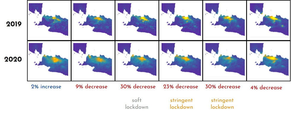
Figure 4. NO2 concentration Jakarta Raya monthly average Jan-Jun 2019 (baseline months) versus Jan-Jun 2020 (COVID-19 months).
This could be indicative of the drop in road transit and industrial activity during those months due to the bans and restrictions put in place by the government.
Efforts on the part of both citizens and policymakers to improve awareness of air quality are critical public health and governance efforts. The next steps for the Big Data NO2 Observatory include advancing the platform with new features, validation methods, and expanding into other regions. Space4Good looks forward to the impacts these insights will provide to the World Bank, as well as local communities affected by these trends.
Would you like more information or are you interested in collaborating with Space4Good? Visit our website or contact us via hello@space4good.com.


Comments